Take the map of the lower 48 US states (pictured); superimpose Alaska on the same scale. Approximately how far across this map could it stretch?
If you could move Alaska south and place it over the contiguous United States in such a way that all its land would fit, it would not only go from Minnesota down to Texas, it would stretch all the way from Florida across to California. Here is how it could look:
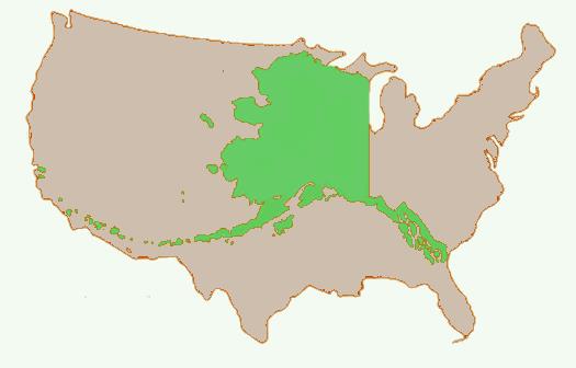
Now let's see how this works out in numbers: obviously, the exact distances depend on how we fit the Alaska map over the "lower-48" map. At its maximum Alaska is 2,261 miles (3,639 km) wide and stretches from Longitude 130°W to 172°E; as the crow flies it is 2179 miles (3509 km) from Attu Station, AK to Ketchikan, AK. To fit the Alaska map on the lower-48 we need an as-the-crow-flies distance from somewhere on the California coast to Florida:
San Diego CA to Jacksonville FL is 2,092 miles (3,347 km)
San Francisco CA to Jacksonville FL is 2,372 miles (3817 km)
So, yes the Alaska map stretches across the whole of the coast-to-coast map of the lower-48.
More Info:
en.wikipedia.org
What are your thoughts on this subject?
40 Comments
spower
This is a terribly worded, misleading question. It suggests a comparison of total area of Alaska compared to the continental US. Alaska does not stretch across "100%" of the US. If it did, it would cover it entirely!

Arno Janssen
A very bad worded question.

Hal Rose
That is NOT 100%!!!! 100% would cover 100%
garyjohnsusmc
Very poorly worded and misleading question. It doesn't cross about 100 percent, that is more like 80 percent.

Kathy Miller DePatie Simmons
That is just a misleading question,
billyboy915
East to west, Alaska spans 2400 miles.
The lower 48 states span approximately 2800 miles.
How do we get 100% from that?
This is a bogus Q&A. How did this pass review?
The answer should be approximately 86%!
billyboy915
That is not 100%. There are hundreds of miles east not spanned.
Was this quiz not reviewed?

Joseph A. Robitaille
That stinks.

Pat Wells
Question is really misleading. It doesn't cover 100% of the U.S.; it covers about 21%. Good idea, Frank, but the question needs to be reworded.

Mary Gini Fudge Chapman
I agree, Spower.

Ray R Walsh Jr.
In actual area it would only cover 21% of the lower 48 states.

Ken Putnam
I'm going to award Frank honorary Clone status for this one
Ken Putnam
lhreese,
Take the map of the lower 48 US states
billyboy915
Richard D. Boyle,
I disagree. Touching coast to coast at the shortest span is not 100%.
East to west, Alaska spans 2400 miles.
The lower 48 states span approximately 2800 miles.
How do we get 100% from that?
This is a bogus Q&A. How did this pass review?
The answer should be approximately 86%!

lhreese
Ha! What about Hawaii too?
Richard D. Boyle
Tough question but correct answer. 100% refers to width of the US west to East and width of Alaska west to East. LA to JAX or San Francisco to NYC are both closer to 100% than any of the other options by far. Area was never an issue. Width was key. Answer is correct but it was counterintuitive.