Which body of water, supplying much of the irrigation and drinking water to many of the Great Plains states, is a pivotal concern in a current environmental battle?
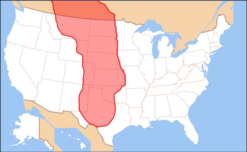
The picture above is simply a rough map of the Great Plains.
The Ogallala Aquifer is a shallow water table aquifer underlying 8 states of the Great Plains. One of the world's largest aquifers, it underlies an area of approximately 174,000 sq mi (450,000 km2) in portions of eight states (South Dakota, Nebraska, Wyoming, Colorado, Kansas, Oklahoma, New Mexico, and Texas). It was named in 1898 by geologist N. H. Darton from its type locality near the town of Ogallala, Nebraska. The aquifer is part of the High Plains Aquifer System, and rests on the Ogallala Formation, which is the principal geologic unit underlying 80% of the High Plains.
More Info:
en.wikipedia.org
What are your thoughts on this subject?
23 Comments

Joseph A. Robitaille
I believe it is past time to conserve water by using waste water as the Israelis do in their country. The more people who live in this country puts a heavy drain on our water and air resources
argyleranger
Joseph A. Robitaille, 'tis a partial answer. I, too, am ready to use "gray" water. But at thje same time the pathological use of 10,000 gallons of water to create 1 gallon of alcohol ol to be burned up in gasohol is the most ridiculous thing we currently do.
elizawheeler
I must have a filthy mind, that looks X rated.

Howard Groopman
Aquifer misspelled.

larrywagner
Maybe a lot of you read up on It. Its being pumped dry, and no replacement will happen in our lifetime.
silrem
Double chance successful with 2nd push.
Gold Toy Box
Going to be a political problem, if not already. Why should one state try to conserve water while an another state continues to pump unregulated. As always the side that raises the most money wins.
Tim Hensley
Too bad its spelled wrong in the question.
Jeff Southard
Map is a little off -- the aquifer does not extend all through eastern Kansas.

Steven Ernest Scott
Gregory W Irwin, *you're

Gregory W Irwin
If your referring to an underground aquifer, I believe this would qualify as a trick question, just saying!
rawe
maybe states not mentioned get their water from another sauce?

chichicleopatra
Never heard of

ninakamwene
No idea

Deena Grady
Why is there no mention of Montana and North Dakota? The map shows all of North Dakota and more than 3/4 of Montana have the same "red" mapping as the other 8 states mentioned.

Marcella Kosse
I never heard of the aquifer, but by its name, deduced what it was for and answered correctly.